Saturday 3 August 2013

Rainbow

It is always a joy to see a rainbow, especially when it's complete.  A reminder from God that he will never completely flood the world again - his promise following the account of Noah and the ark.

If you look very carefully, you can see a second, outer, rainbow forming.  On this occasion nothing much happened with the second rainbow, or at least from where I was at the time.  There hadn't been any rain locally but I guess there would have been a good shower nearby.

Monday 15 July 2013

Circumzenithal arc

Look carefully in the middle - the rainbow-like Circumzenithal arc
Apparently if the sun is higher than 32.2 degrees in the sky you won't see one of these rare and spectacular sights.  It is a rainbow-like effect in the sky and only ever seen as a arc and contains refracted ice.  It seems so strange seeing a "rainbow" on such a hot, dry day!

Generally the arc will look like a smile but you still have to look carefully: these are the only photographs I have of Circumzenithal arcs and believe me, they're not easy to photograph.


Cirrus Uncinus

Cirrus Uncinus
We were all amazed by this wonderful display of clouds overhead.  It was early evening and we'd just finished our evening meal outside on our patio - this is a rare thing to do in the British summers over recent years!  You can also spot a Contrail (a condensation trail) from an aircraft which passed over earlier on.  The feathery edges of this display was stunning.  See below for others taken shortly before; even on calm days with little wind the high level clouds can still move around quite briskly.


Sunday 14 July 2013

Cirrus Uncinus

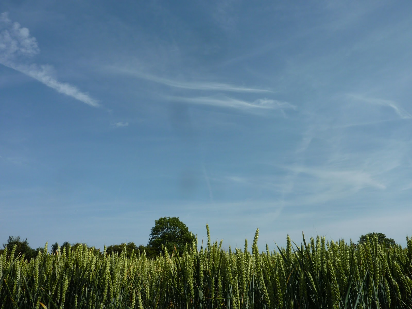
Mid summer Cirrus Uncinus
Just a small example of these clouds which are always a welcome sight.  These are high level clouds at 20,000 feet or more and a sign of good sunny weather, with plenty of high pressure.  They are actually composed of ice crystals way up there and picked up by the wind; the longer the wispy trail, the stronger the wind.

Taken today, 14th July in the middle of a very warm and sunny spell of weather.  Also spotted today:


Yes, I know the photograph below is not of some clouds as such.  It was taken in a woodland area on the top of a hill shrouded in low cloud.  So it is, sort of, a picture of a cloud - a nice misty scene early in the morning while it was still quite cool.  Gradually the sun warmed up and the low level cloud melted away, leading to the pictures above during the afternoon.


Wednesday 5 June 2013

Two French rainbows


Both of these rainbows were photographed last week on a holiday trip to France.  With the top rainbow, as seen from the car ferry, I don't think I have ever been so close to a rainbow!  In being over the see, it sadly dispel the myth of a pot of gold always being at the end.

The second was from the Brittany region and, as is often the case, the formation applied just after a rainy afternoon..

Tuesday 2 April 2013

Stratocumulus

This is probably my favourite cloud picture to date but I must confess it has had a little computer enhancement.  Taken on the ever-changing sea front at Weston-Super-Mare you can see there's quite a lot going on in this photograph with the clouds evolving.  Taken in the late afternoon one November, it was blustery as it often is on that stretch of coastline.


Stratocumulus


Steepholm Island in the Bristol Channel photographed from Weston-Super-Mare one August.  The sea is a little choppy with the wind increasing there were some showers around and not far away.

Cirrus

Some high altitude Cirrus clouds above London and without much cloud activity as such.  Unless you count the condensation trails from aircraft having flown over sometime earlier in the afternoon.

The Shard is claimed to be the tallest building in Western Europe at 310 metres; 1016 feet.  Photographed here while still under construction it is clearly a dramatic addition to the London skyline and will provide a mixture of commercial and residential accommodation.  I can only imagine the stunning views from the upper floors, unless they are shrouded in cloud that is!


Cirrus

Some lovely Cirrus clouds photographed one warm, sunny afternoon in the summer while out for a bike ride with my youngest daughter.  She protested when I stopped to photograph this but the situation was fixed when I turned the camera towards her (yes, I should have done that first!).

Not too sure which variety; possibly Cirrus floccus.


Cirrus


I'm sure this is a Cirrus cloud but not too sure which variety.  Cirrus clouds are always lovely to see as a sign of pleasant weather and can be at around 20,000ft.

Lower down there is (what appears to be) a string of Cumulus mediocris; a low hanging cloud which is sometimes grouped together by the wind.  Otherwise earlier in the day they may have been Cumulus congests.

Cumulus humilis


Taken early one evening from Birdlip Hill, Gloucestershire and looking west.  The  photograph above is one of my favourite cloud shots of all time: I like it for the simplicity and the soft colours blending in with each other.  These clouds float around at about 2,000ft give or take a little.

These clouds are still forming as their bases haven't come together completely.  They're common in warm fine weather and sometimes rise further to become Cumulus mediocris or cumulus congestus if there has already been rain.  Happily this didn't happen on this day, they rolled by as we drove home in lovely weather.

The photograph on the left was taken a little sooner or later from the same spot and has the Forest of Dean hills in the bottom left and the Malvern Hills in the bottom right.

Cumulus congestus

 Dramatic Comulus congestus clouds which I always seem to notice most of all in May, here in the UK.  They can be threatening with heavy showers and develop very vigourously.

The overall size of these can sometimes be stunning and you can almost see the internal convections taking place as the fluffy tops continue to bubble away.

Stratos nebulosus


I might have the classification of this completely wrong but I like the comical sheep if nothing else!  It was taken early one still summer morning in Cumbria, UK.  There were clumps of low level cloud floating around and very moist.

Stratocumulus


Heavy threatening clouds in the middle of an English summer!  Stratocululus photographed with the Hitchin lavender fields in Hertfordshire UK in the foreground.  We got very wet that day!


Cumulus mediocris

An example of Cumulus mediocris, where such clouds are arranged and moulded into shape by the wind.  I remember this clearly and it was almost eerie seeing this ribbon of heavy cloud forming a dark line in an otherwise cloudy sky.

Cirrostratus


I think this is a straight forward Cirrostratus arrangement.  They are high level clouds and the wispiness is clearly seen against a clear blue sky.

We're looking at ice crystals forming, often ahead of an incoming depression with its lower air pressure - a sure sign of this happening is seeing these clouds grow and thicken - a sure sign of poor weather approaching.  There are variations of these clouds including Cirrocumulus which is a sure sign of approaching wet weather.

The added bonus with this photograph are the vapour condensation trails from aircraft which have passed overhead, also known as "contrails".

Monday 1 April 2013

Cumulonimbus calvus


Taken during mid October and includes a skyline in London with the magnificent St Paul's Cathedral on the left.  Although it looked as if a shower may have been threatened, London stayed dry that day.


Stratus fractus

Stratus fractus are also known as 'messenger' clouds and can be seen creeping over this mountainous area in Spain.  They are small clumps or shreds of clouds.

If you happen to be in this cloud, you'll only get wet through the drizzle like moisture as these are unlikely to be effective in producing rain as they pass over.  It's possible the clouds above may cause rain and this will fall through the lower level Stratus fractus clouds in order to confuse people like me!

Cirrus fibratus


This was taken on the Mediterranean coast of Spain during a pleasant holiday at the end of October.  The weather was fine but a depression arrived during the next few days.

These are lovely high level clouds at around 20,000 feet and are gradually invading the sky because of the approaching lower pressure.  They sometimes thicken and form into thicker strands, gradually joining up.

You can see they are not alone as there are some lower level clouds creeping in on the right hand side which are possibly Cumulus.

Cumulonimbus capillatus


A dark brooding example somewhat exaggerated in monochrome which I occasionally use to photograph clouds.  It's almost like a piece of Mahler's 5th symphony.

Although this is just a section, these can be huge structures towering vast heights into the sky.  These often occur in the summer during hot stormy weather and often heavy rain storms will follow, possibly with hail or thunder.  I love these!

These are energetic clouds arising from cumulus congests through powerful upward drafts which can develop into Cumulonimbus capillatus shown here.

Sunday 31 March 2013

Stratocumulus cumulogenitus

Relatively low clouds in a state carrying much moisture and leading to possible localised showers.

Altocumulus cumulogenitus


Possibly a Altocumulus cumulogenitus cloud, taken at a distance on a summer's day in Bedfordshire, UK.  I believe this is formed from a cumulus congests cloud as the cloud's upward growth is curtailed by the lower temperature in the higher atmosphere hence the "spreading out" effect.

Cumlulonimbus calvus


A section of a cloud carrying plenty of moisture which can grow to a considerable height, representing the next stage of the sizeable cumulus congestus clouds.